Atlas of Ningxia: Difference between revisions
Jump to navigation
Jump to search
Content deleted Content added
typo |
m Moving from Category:Atlas of China to Category:WikiAtlas of China |
||
| (15 intermediate revisions by 7 users not shown) | |||
| Line 3: | Line 3: | ||
|thumb = Flag of the People's Republic of China |
|thumb = Flag of the People's Republic of China |
||
|short name = Ningxia |
|short name = Ningxia |
||
|native = |
|native = 宁夏 |
||
|long name = Ningxia Hui Autonomous Region |
|long name = Ningxia Hui Autonomous Region |
||
|country = People's Republic of China |
|country = People's Republic of China |
||
|map = China |
|map = China Ningxia.svg |
||
|location = Central Asia |
|location = Central Asia |
||
|status = Autonomous region of China |
|status = Autonomous region of {{atp|China}} |
||
| ⚫ | |||
|capital = Yinchuan (銀川) |
|||
| ⚫ | |||
| ⚫ | |||
|capital = 銀川<ref>{{romzh|Yínchuān}}</ref> (Yinchuan) |
|||
| ⚫ | |||
|surface = 66,000 |
|surface = 66,000 |
||
|language = Chinese |
|language = Chinese |
||
|religion = Chinese folk religion, Islam |
|religion = Chinese folk religion, Islam |
||
|country-the = the |
|country-the = the |
||
|intro = Ningxia, full name Ningxia Hui Autonomous Region, is a Hui autonomous region of the People's Republic of China, located on the northwest Loess highland, the Yellow River flows through a vast area of its land. The capital of the region is Yinchuan. |
|intro = Ningxia, full name Ningxia Hui Autonomous Region, is a Hui autonomous region of the People's Republic of China, located on the northwest Loess highland, the Yellow River flows through a vast area of its land. The capital of the region is Yinchuan. In the north it borders {{atp|Inner Mongolia}}. |
||
}} |
}} |
||
====In Chinese==== |
|||
| ⚫ | |||
| ⚫ | |||
{{general-maps|country=Ningxia}} |
{{general-maps|country=Ningxia}} |
||
{{left|Image: |
{{left|Image:Ningxia_province.png|Map of Ningxia}} |
||
{{left|Image:Ningxia. |
{{left|Image:China Ningxia.svg|Location of the Region}} |
||
<gallery> |
<gallery> |
||
Image:Yinchuan.png|[[Yinchuan]] (银川) City, the capital of The Autonomous Region |
Image:Yinchuan.png|[[Yinchuan]] (银川) City, the capital of The Autonomous Region |
||
| Line 32: | Line 31: | ||
{{atlas-end}} |
{{atlas-end}} |
||
[[Category:WikiAtlas of China|Ningxia]] |
|||
[[Category:Atlas of Asia|Ningxia]] |
[[Category:Atlas of Asia|Ningxia]] |
||
[[Category:Maps of Ningxia]] |
[[Category:Maps of Ningxia]] |
||
[[Category:Ningxia]] |
[[Category:Ningxia]] |
||
[[Category:Atlas entries in progress fase 9]] |
[[Category:Atlas entries in progress fase 9]] |
||
| ⚫ | |||
[[ar:نينغشيا]] |
|||
[[bg:Нинся-хуейски автономен регион]] |
[[bg:Нинся-хуейски автономен регион]] |
||
[[bo:ཉིང་ཤ་ཧུའི་རིགས་རང་སྐྱོང་ལྗོངས།]] |
|||
[[ca:Ningxia]] |
[[ca:Ningxia]] |
||
[[cs:Ning-sia]] |
[[cs:Ning-sia]] |
||
| ⚫ | |||
[[da:Ningxia]] |
[[da:Ningxia]] |
||
[[de:Ningxia]] |
[[de:Ningxia]] |
||
| ⚫ | |||
[[en:Ningxia]] |
[[en:Ningxia]] |
||
| ⚫ | |||
[[eo:Ningŝjao]] |
[[eo:Ningŝjao]] |
||
| ⚫ | |||
[[et:Ningxia]] |
|||
[[eu:Ningxia]] |
[[eu:Ningxia]] |
||
[[ |
[[fi:Ningxia]] |
||
[[fr:Région autonome huí du Níngxià]] |
|||
| ⚫ | |||
[[gv:Ningxia]] |
|||
| ⚫ | |||
[[hak:Nèn-ha]] |
|||
| ⚫ | |||
[[hi:निंग्श़िया]] |
|||
[[hu:Ninghszia]] |
|||
[[id:Ningxia]] |
[[id:Ningxia]] |
||
[[it:Ningxia]] |
[[it:Ningxia]] |
||
| ⚫ | |||
| ⚫ | |||
[[ka: |
[[ka:ნინსია-ხუეი]] |
||
[[kk:Нинся]] |
|||
| ⚫ | |||
[[lt:Ningsia]] |
[[lt:Ningsia]] |
||
| ⚫ | |||
| ⚫ | |||
[[ms:Ningxia]] |
|||
[[nl:Ningxia]] |
[[nl:Ningxia]] |
||
[[nn:Ningxia]] |
|||
| ⚫ | |||
[[no:Ningxia |
[[no:Ningxia]] |
||
[[ug:Ningshya Xuyzu Aptonum Rayoni]] |
|||
[[pl:Ningxia]] |
[[pl:Ningxia]] |
||
[[pnb:ننگزیا]] |
|||
[[pt:Ningxia]] |
[[pt:Ningxia]] |
||
[[ro:Ningxia]] |
|||
[[ru:Нинся-Хуэйский автономный район]] |
[[ru:Нинся-Хуэйский автономный район]] |
||
[[ |
[[sco:Ningxia]] |
||
[[sh:Ningxia]] |
|||
[[sr:Нингсја]] |
|||
[[su:Ningxia]] |
|||
[[sv:Ningxia]] |
[[sv:Ningxia]] |
||
[[sw:Ningxia]] |
|||
[[th:เขตปกครองตนเองหนิงเซี่ยหุย]] |
|||
[[tl:Ningxia]] |
|||
[[tr:Ningxia Huizu Özerk Bölgesi]] |
|||
[[ug:نىڭشيا خۇيزۇ ئاپتونۇم رايونى]] |
|||
[[uk:Нінся-Хуейський автономний район]] |
|||
[[vi:Ninh Hạ]] |
|||
[[war:Ningxia]] |
|||
[[xal:Нинша]] |
|||
[[zh:宁夏回族自治区]] |
[[zh:宁夏回族自治区]] |
||
[[zh-min-nan:Lêng-hā Hôe-cho̍k Chū-tī-khu]] |
|||
Latest revision as of 12:28, 10 September 2024

|
Wikimedia Commons Atlas of the World The Wikimedia Atlas of the World is an organized and commented collection of geographical, political and historical maps available at Wikimedia Commons. Discussion • Update the atlas • Index of the Atlas • Atlas in categories • Other atlases on line |
The introductions of the country, dependency and region entries are in the native languages and in English. The other introductions are in English.
|
| ||||||||||||||||||||||||||||||||||||||

General maps

|
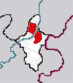
Map of Ningxia |

|
Location of the Region |
-
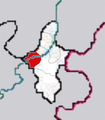
 Yinchuan (银川) City, the capital of The Autonomous Region
 -
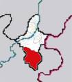 Guyuan (固原) City
 -
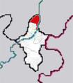 Shizuishan (石嘴山) City
 -
 Wuzhong (吴忠) City
 -
 Zhongwei (中卫) City


Notes and references
|
General remarks:
|