File:Teutonic Order 1410.png: Difference between revisions

From Wikimedia Commons, the free media repository
Jump to navigation Jump to search
Content deleted Content added
{{Other versions/Teutonic Order maps}}
Line 1: Line 1:
== {{int:filedesc}} ==
{{Information
{{Information
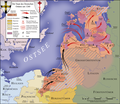
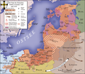
|Description={{en|1=Map of the monastic state of the Teutonic Knights between 1260 and 1410}}
|Description={{Description/Teutonic Order|1260|1410}}
{{de|1=Der Staat des Deutschen Ordens zwischen 1260 und 1410}}
|Source=*Dieter Zimmerling: ''Der Deutsche Ritterorden''. 2. Auflage 1991. Econ Verlag, Düsseldorf, Wien, New York 1989, {{ISBN|3-430-19959-X}}
|Source=*Dieter Zimmerling: ''Der Deutsche Ritterorden''. 2. Auflage 1991. Econ Verlag, Düsseldorf, Wien, New York 1989, {{ISBN|3-430-19959-X}}
*Hermann Kindler, Werner Hilgemann: ''dtv-Atlas zur Weltgeschichte''. Lizenzausgabe für Bertelsmann Club HmbH und diverse Buchclubs. Deutscher Taschenbuch Verlag, München ohne Jahr. Band 1
Line 16: Line 15:
|Date=2010-06-10
|Date=2010-06-10
|Permission=
|Permission=
|other_versions={{Other versions/Teutonic Order maps}}
|other_versions=<gallery> File:Deutscher_Orden_1410.png|[[File:Qsicon exzellent 2.png|15px]] German: Der Staat des Deutschen Ordens zwischen 1260 und 1410</gallery>
}}
}}

== Part of ==
<gallery caption="The state of the Teutonic Order">
File:Teutonic_Order_1260.png|The state of the Teutonic Order in 1260
File:Teutonic_Order_1410.png|The state of the Teutonic Order from 1260 to 1410
File:Teutonic_Order_1466.png|The state of the Teutonic Order after 1466
</gallery>


== {{int:license-header}} ==
Line 31: Line 23:


[[Category:State of the Teutonic Order]]
[[Category:State of the Teutonic Order]]
[[Category:English-language maps]]
[[Category:English-language maps showing history]]
[[Category:Maps of Prussia]]
[[Category:Maps of Prussia]]
[[Category:Maps showing 15th-century history]]
[[Category:Maps showing 15th-century history]]

Revision as of 16:20, 22 January 2022

Captions

Captions

Add a one-line explanation of what this file represents

Summary

Description

[edit]

If you can, help make this description accessible to all by translating it into other languages. – Thanks!
Deutsch: Der Staat des Deutschen Ordens, 1260 bis 1410
date QS:P,+1500-00-00T00:00:00Z/6,P580,+1260-00-00T00:00:00Z/9,P582,+1410-00-00T00:00:00Z/9
English: Map of the monastic state of the Teutonic Knights, from 1260 until 1410
date QS:P,+1500-00-00T00:00:00Z/6,P580,+1260-00-00T00:00:00Z/9,P582,+1410-00-00T00:00:00Z/9
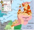
Español: Mapa del Estado monástico de los Caballeros Teutónicos, de 1260 a 1410
date QS:P,+1500-00-00T00:00:00Z/6,P580,+1260-00-00T00:00:00Z/9,P582,+1410-00-00T00:00:00Z/9
Italiano: Mappa dello stato monastico dei Cavalieri Teutonici, dal 1260 al 1410
date QS:P,+1500-00-00T00:00:00Z/6,P580,+1260-00-00T00:00:00Z/9,P582,+1410-00-00T00:00:00Z/9
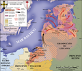
Português: Mapa do estado eclesiástico dos Cavaleiros Teutónicos, de 1260 a 1410
date QS:P,+1500-00-00T00:00:00Z/6,P580,+1260-00-00T00:00:00Z/9,P582,+1410-00-00T00:00:00Z/9
Date
Source
  • Dieter Zimmerling: Der Deutsche Ritterorden. 2. Auflage 1991. Econ Verlag, Düsseldorf, Wien, New York 1989, ISBN 3-430-19959-X
  • Hermann Kindler, Werner Hilgemann: dtv-Atlas zur Weltgeschichte. Lizenzausgabe für Bertelsmann Club HmbH und diverse Buchclubs. Deutscher Taschenbuch Verlag, München ohne Jahr. Band 1
  • Geoffrey Barraclough [Hrsg.]: Atlas der Weltgeschichte. Bechtermünz Verlag, Augsburg 1997, ISBN 3-86047-178-3
  • Franklin H. Littell: Atlas zur Geschichte des Christentums. 2. Sonderauflage. Brockhaus Verlag 1989. ISBN 3-417-24606-7
  • Gerhard Ziegler, Walter Heidenreuter: Karten für den Geschichtsunterricht. Volk und Wissen, Berlin 1954.
  • F. W. Putzgers Historischer Schul-Atlas. Ausgabe 1923. www.maproom.org
  • Ernst Bruckmüller, Peter Claus Hartmann: Putzger Historischer Weltatlas. 102. Auflage. Cornelsen 1992.
  • Dr. Richard Andree: Droysens Allgemeiner Historischer Handatlas. www.maproom.org
  • Karl Spruner, Theodor Menke: Hand-Atlas für die Geschichte des Mittelalters und die neueren Zeit. 3. Auflage. Justus Perthes, Gotha 1880. www.maproom.org
  • Ohne Autor: Abbildung und Beschreibung aller Ritterorden in Europa. Reprint der Originalausgabe von 1792. Reprint-Verlag Leipzig. ISBN 3-8262-1807-8
Author S. Bollmann
Other versions

[edit]

1260
1410
1466

Licensing

I, the copyright holder of this work, hereby publish it under the following licenses:
GNU head Permission is granted to copy, distribute and/or modify this document under the terms of the GNU Free Documentation License, Version 1.2 or any later version published by the Free Software Foundation; with no Invariant Sections, no Front-Cover Texts, and no Back-Cover Texts. A copy of the license is included in the section entitled GNU Free Documentation License.
w:en:Creative Commons
attribution share alike
This file is licensed under the Creative Commons Attribution-Share Alike 3.0 Unported, 2.5 Generic, 2.0 Generic and 1.0 Generic license.
You are free:
  • to share – to copy, distribute and transmit the work
  • to remix – to adapt the work
Under the following conditions:
  • attribution – You must give appropriate credit, provide a link to the license, and indicate if changes were made. You may do so in any reasonable manner, but not in any way that suggests the licensor endorses you or your use.
  • share alike – If you remix, transform, or build upon the material, you must distribute your contributions under the same or compatible license as the original.
You may select the license of your choice.
Kartenwerkstatt
This map has been made or improved in the German Kartenwerkstatt (Map Lab). You can propose maps to improve as well.

File history

Click on a date/time to view the file as it appeared at that time.

Date/TimeThumbnailDimensionsUserComment
current19:57, 12 June 2010Thumbnail for version as of 19:57, 12 June 20101,200 × 1,043 (879 KB)S. Bollmann (talk | contribs)minor fixes
00:21, 12 June 2010Thumbnail for version as of 00:21, 12 June 20101,200 × 1,043 (882 KB)S. Bollmann (talk | contribs)translation fixes
17:26, 10 June 2010Thumbnail for version as of 17:26, 10 June 20101,200 × 1,043 (882 KB)S. Bollmann (talk | contribs)translation fixes
23:20, 9 June 2010Thumbnail for version as of 23:20, 9 June 20101,200 × 1,043 (881 KB)S. Bollmann (talk | contribs){{Information |Description={{en|1=Map of the monastic state of the Teutonic Knights between 1260 and 1410}} {{de|1=Der Staat des Deutschen Ordens zwischen 1260 und 1410}} |Source=*Dieter Zimmerling: ''Der Deutsche Ritterorden''. 2. Auflage 1991. Econ Verl

File usage on other wikis

The following other wikis use this file:

View more global usage of this file.