File:Hungary NUTS 3.svg
Jump to navigation
Jump to search

Size of this PNG preview of this SVG file: 800 × 525 pixels. Other resolutions: 320 × 210 pixels | 640 × 420 pixels | 1,024 × 671 pixels | 1,280 × 839 pixels | 2,560 × 1,679 pixels | 2,440 × 1,600 pixels.
Original file (SVG file, nominally 2,440 × 1,600 pixels, file size: 86 KB)
Captions
Captions
Add a one-line explanation of what this file represents
Summary
[edit]
| Description |
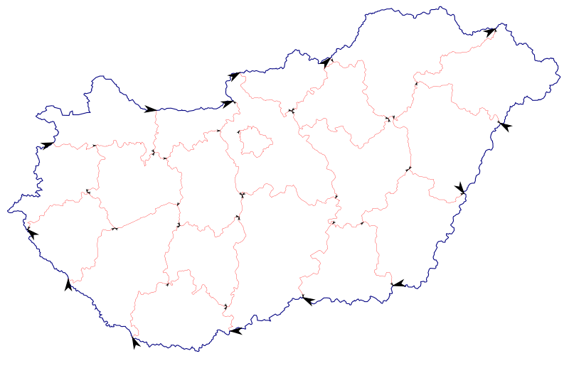
English: A vector map of the NUTS 3 regions of Hungary (counties), with borders delineating the Hungarian country border and the NUTS 2 borders in different colours. Intended as a start point for others to make more colourful maps. The names of the borders are the county names (or "Hungary" for country borders), which goes first is as if it were drawn clockwise, the county that was drawn clockwise comes first, the other (anticlockwise) second. The names have accents and spaces removed. |
| Date | |
| Source | Hungary_NUTS_3.png at Wikimedia Commons |
| Author | User:SimonTrew |
Licensing
[edit]
This file is licensed under the Creative Commons Attribution-Share Alike 3.0 Unported license.
- You are free:
- to share – to copy, distribute and transmit the work
- to remix – to adapt the work
- Under the following conditions:
- attribution – You must give appropriate credit, provide a link to the license, and indicate if changes were made. You may do so in any reasonable manner, but not in any way that suggests the licensor endorses you or your use.
- share alike – If you remix, transform, or build upon the material, you must distribute your contributions under the same or compatible license as the original.
File history
Click on a date/time to view the file as it appeared at that time.
| Date/Time | Thumbnail | Dimensions | User | Comment | |
|---|---|---|---|---|---|
| current | 16:44, 26 November 2009 | | 2,440 × 1,600 (86 KB) | SimonTrew (talk | contribs) | I dunno why the black mask on that label was there. It is not there in Inkscape. Trying again, otherwise I will look on the XML. The labels are not important anyway, it's more to get the borders in vector graphics. |
| 16:44, 26 November 2009 |  | 2,440 × 1,600 (82 KB) | SimonTrew (talk | contribs) | I dunno why the black mask on that label was there. It is not there in Inkscape. Trying again, otherwise I will look on the XML. The labels are not important anyway, it's more to get the borders in vector graphics. | |
| 00:31, 25 November 2009 |  | 2,440 × 1,600 (99 KB) | SimonTrew (talk | contribs) | {{Information |Description={{en|1=A vector map of the NUTS 3 regions of Hungary (counties), with borders delineating the Hungarian country border and the NUTS 2 borders in different colours. Intended as a start point for others to make more colourful maps |
You cannot overwrite this file.
File usage on Commons
There are no pages that use this file.
File usage on other wikis
The following other wikis use this file:
- Usage on en.wikipedia.org