File:POLSKA 14-03-1945.png
Jump to navigation
Jump to search

Size of this preview: 630 × 599 pixels. Other resolutions: 252 × 240 pixels | 504 × 480 pixels | 701 × 667 pixels.
Original file (701 × 667 pixels, file size: 180 KB, MIME type: image/png)
Captions
Captions
Add a one-line explanation of what this file represents

|
This historical map image could be re-created using vector graphics as an SVG file. This has several advantages; see Commons:Media for cleanup for more information. If an SVG form of this image is available, please upload it and afterwards replace this template with
{{vector version available|new image name}}.
It is recommended to name the SVG file “POLSKA 14-03-1945.svg”—then the template Vector version available (or Vva) does not need the new image name parameter. |
Summary
[edit]
| Description |
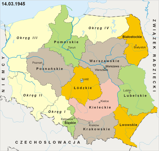
Podział administracyjny Polski w dniu 14 marca 1945 Administrative division of Poland as of March 14, 1945 |
| Source | Own work na podstawie map administracyjnych Polski zawartych w Wielkim atlasie historycznym Wydawnictwa Demart (Warszawa 2002) i Narodowym atlasie Polski wydanym przez Polską Akademię Nauk (1973-1978) oraz powojennego prawodastwa polskiego publikowanego w Dzienniku Ustaw |
| Author | Aotearoa |
Licensing
[edit]
I, the copyright holder of this work, hereby publish it under the following license:

|
Permission is granted to copy, distribute and/or modify this document under the terms of the GNU Free Documentation License, Version 1.2 or any later version published by the Free Software Foundation; with no Invariant Sections, no Front-Cover Texts, and no Back-Cover Texts. A copy of the license is included in the section entitled GNU Free Documentation License. |
| This file is licensed under the Creative Commons Attribution-Share Alike 3.0 Unported license. | ||
| ||
| This licensing tag was added to this file as part of the GFDL licensing update. |
File history
Click on a date/time to view the file as it appeared at that time.
| Date/Time | Thumbnail | Dimensions | User | Comment | |
|---|---|---|---|---|---|
| current | 07:09, 28 April 2009 | | 701 × 667 (180 KB) | Aotearoa (talk | contribs) | drobne zmiany |
| 12:08, 22 August 2007 | 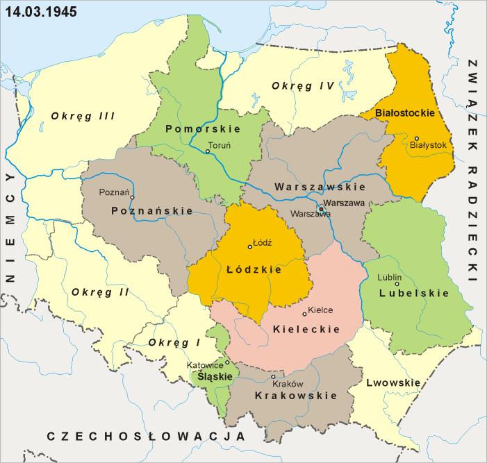 | 701 × 667 (149 KB) | Aotearoa (talk | contribs) | == Summary == {{Information |Description=Podział administracyjny Polski w dniu 14 marca 1945<br>Administrative division of Poland as of March 14, 1945 |Source=self-made |Date= |Author= Aotearoa }} == Licensing == {{self|GFDL}} [[Categ |
You cannot overwrite this file.
File usage on Commons
The following page uses this file:
File usage on other wikis
The following other wikis use this file:
- Usage on da.wikipedia.org
- Usage on en.wikipedia.org
- Usage on es.wikipedia.org
- Usage on fr.wikipedia.org
- Usage on ja.wikipedia.org
- Usage on nl.wikipedia.org
- Usage on no.wikipedia.org
- Usage on pl.wikipedia.org
- Usage on ro.wikipedia.org