User:TheWxResearcher
(Redirected from User:Wikihelp7586)
- Link to Wiki page: TheWxResearcher if you want to know more about my cause on Wiki Commons/Wikipedia
Status of my account
[edit]Disclaimers
[edit]- I'll retrieve images of tropical cyclones or other global weather phenomena primarily from polar-orbiting satellites such as Terra-MODIS, Aqua-MODIS, Suomi-NPP, NOAA-20, NOAA-21, Sentinel-3B, and Sentinel-2A due to their ability to capture high-quality imagery. However, I have a partial preference for images from geostationary satellites like GOES-16, GOES-17, GOES-18, Himawari-8, Himawari-9, and Meteosat-12 (future), as they provide frequent updates every few minutes. When it comes to satellite imagery of cities or other specific geographical features, I'll source it from Sentinel-2, Landsat, or even the International Space Station if the crew onboard captures relevant images.
Times I will upload during an active Tropical Cyclone
[edit]During the active lifespan of a Tropical Cyclone, I regularly retrieve imagery from NASA Worldview, NOAA GOES image viewer, and the University of Wisconsin-Madison's RealEarth website. This typically occurs twice a day, though it may increase to three times if the storm peaks in the evening, and even four times if the peak happens at night. The frequency depends on my schedule, whether I'm at work, school, or occupied with other tasks, although assistance from others is always welcome.
Here's the breakdown of the image retrieval schedule:
- Morning: Likely sourced from Terra-MODIS or one of the Geostationary satellites like GOES, Himawari, or Meteosat.
- Afternoon: Very likely sourced from Aqua-MODIS, NOAA-20, and Suomi-NPP.
- Evening: Very likely sourced from the Geostationary satellites due to the limited availability of polar-orbiting passes during this time.
- Night: Only if the peak occurs during nighttime, during a gibbous or full moon, or if the storm's peak intensity is 5% or more (in knots) higher than its intensity at sunset or sunrise between the new moon and half-moon phases.
- Examples of what I upload
-
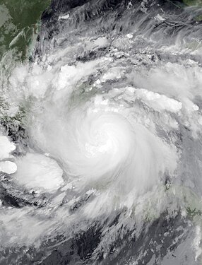
 Example 1, Daytime true color imagery, is the most common image I upload. It is used if the peak occurs at or around Terra-MODIS, Aqua-MODIS, Suomi-NPP, or NOAA-20 pass over)
 -
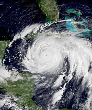
 Example 2, True-Color GOES imagery, These images are my second most common uploads. These images will be used if the peak occurs outside of a Polar-Orbiting satellite pass over
 -
 Example 3, True-Color Himawari imagery, These images are also my second most common uploads. These images will be used if the peak occurs outside of a Polar-Orbiting satellite pass over
 -
 Example 4, Alternative Nighttime imagery Suomi-NPP's Black Marble sensor radiance, these are my second-rarest uploads since I have to wait during a particular time of the month when the Moon is at its gibbous phase or its full phase, and Suomi-NPP has to fly directly or nearly fly directly over the storm when it peak or around its peak during the night.
 -
 Example 5, Night IR images. they're only used in a last resort type of situation (between a new moon to the half moon), THEY'RE ONLY USED if the storm's peak is 5%+ higher (in knots) than the storm's intensity at sunset or sunrise or if the storm's structure appears better compared to the last of the true-color visible imagery, other than that expect images like Example 2 (for NATL or EPAC) or 3 (for WPAC, AUS Reg, and SPAC) because I'm trying to be more realistic towards our readers and users and follow the WPTC/IMG policy thanks for understanding if you're reading this :).
 -
 Example 5, Colored images of older tropical cyclones. These are the rarest uploads. If you see me uploading them, I'm probably just uploading them because I have nothing else to do at a particular moment.
 -
 Example 6, Satellite pictures of extratropical cyclones (Winter storms, tornado outbreaks, flooding events), typically I will upload these during Winter or tornado season. Still, I can upload them year-round since these storms happen every day.
 -
 Example 7, Satellite pictures of cities and metropolitan areas.
 -
 Example 8, Sentinel-3 satellite imagery, these images aren't meant to be used for peak intensity images. They're just for show since, most of the time. The Sentinel-3 satellites don't directly pass over tropical cyclones. Still, if there are no peak images from NASA or Geostationary satellites, these are warranted.


.jpg)


