
Plăieșii de Jos: Difference between revisions
Marcus Cyron (talk | contribs) m (Script) File renamed: File:CoA of Kászon.jpg → File:ROU HR Plaiesii de Jos CoA.jpg File renaming criterion #6: Harmonize file names of a set of images (so that only one part of all names differs... |
ill links |
||
| (20 intermediate revisions by 7 users not shown) | |||
| Line 1: | Line 1: | ||
{{Infobox Romanian subdivision |
|||
{{Infobox settlement <!--more fields are available for this Infobox--See Template:Infobox settlement--> |
|||
|type = commune |
|||
|coordinates_display = inline,title |
|||
|county = Harghita |
|||
|coordinates_region = RO |
|||
| ⚫ | |||
|subdivision_type = [[Countries of the world|Country]] |
|||
| |
|other_name = Kászon |
||
| ⚫ | |||
|timezone=[[Eastern European Time|EET]] |
|||
|image_skyline = Balasi kastely.jpg |
|||
|utc_offset=+2 |
|||
|image_caption = {{ill|Balási Castle in Imper|lt=Balási Castle|ro|Castelul Balási din Imper}} in Imper |
|||
|timezone_DST=[[Eastern European Summer Time|EEST]] |
|||
|image_location = |
|||
|utc_offset_DST=+3 |
|||
| ⚫ | |||
|map_caption = Location |
|map_caption = Location in Harghita County |
||
| ⚫ | |||
|leader_name = Zoltán András<ref>{{cite web |url=https://prezenta.roaep.ro/locale27092020/romania-pv-final |title=Results of the 2020 local elections |publisher=Central Electoral Bureau |access-date=9 June 2021 |df=dmy-all}}</ref> |
|||
|other_name=Kászon| |
|||
|leader_party = UDMR |
|||
| ⚫ | |||
|term = 2020–2024 |
|||
| ⚫ | |||
|coordinates = {{coord|46|14|N|26|06|E|region:RO|display=inline,title}} |
|||
|subdivision_type1=[[Counties of Romania|County]]| |
|||
|elevation = 719 |
|||
subdivision_name1=Harghita County| |
|||
|elevation_min = |
|||
|subdivision_type2=[[Subdivisions of Romania|Status]]| |
|||
|elevation_max = |
|||
subdivision_name2=[[Communes of Romania|Commune]] |
|||
| ⚫ | |||
|settlement_type=Commune|| |
|||
|population_as_of = |
|||
|leader_title=[[Mayor]]| |
|||
| ⚫ | |||
leader_name=Zoltán András| |
|||
|population_footnotes = |
|||
| ⚫ | |||
| ⚫ | |||
|leader_party=[[Democratic Union of Hungarians in Romania]]| |
|||
|area_code = +40 266 |
|||
|population_density_km2 = 9.84 |
|||
|website = {{url|https://www.kaszon.ro}} |
|||
|postal_code_type=[[List of postal codes in Romania|Postal Code]] |
|||
| ⚫ | |||
|area_code=[[Romania telephone area codes|+40 266]]| |
|||
|pushpin_map=Romania |
|||
|area_code=[[Romania telephone area codes|+40 266]]| |
|||
| ⚫ | |||
|latd=46|latm=14|lats=0|latNS=N|longd=26|longm=6|longs=0|longEW=E|| |
|||
website=[http://www.kaszon.ro www.kaszon.ro] |
|||
}} |
}} |
||
''' |
'''Plăieșii de Jos''' ({{lang-hu|Kászonaltíz}} or ''Kászon'', <small>Hungarian pronunciation: </small>{{convertIPA-hu|ˈ|k|á|sz|o|n|}}) is a commune in [[Harghita County]], [[Romania]]. It lies in the [[Székely Land]], an ethno-cultural region in eastern [[Transylvania]]. The commune is composed of five villages: Cașinu Nou (''Kászonújfalu''), |
||
Iacobeni (''Kászonjakabfalva''), Imper (colloquially Imper-Doboi or Doboi, ''Kászonimpér''), Plăieșii de Jos, and Plăieșii de Sus (''Kászonfeltíz''). |
|||
== |
== Geography == |
||
The commune lies on the banks of the [[Cașin (Râul Negru)|Cașin River]] and its tributary, [[Pârâul Primejdios]], in a hilly area at the foot of the [[Ciuc Mountains]]. It is located at the southeastern extremity of Harghita County, {{cvt|42|km}} from the county seat, [[Miercurea Ciuc]], on the border with [[Covasna County]] (to the south) and [[Bacău County]] (to the east). |
|||
The commune is composed of five villages: |
|||
{| class="wikitable collapsible sortable" |
|||
!In [[Romanian language|Romanian]]!!In [[Hungarian language|Hungarian]] |
|||
|- |
|||
|Caşinu Nou||Kászonújfalu |
|||
|- |
|||
|Iacobeni||Kászonjakabfalva |
|||
|- |
|||
|Imper{{ref label|A|a|none}}||Kászonimpér |
|||
|- |
|||
|Plăieşii de Jos||Kászonaltíz |
|||
|- |
|||
|Plăieşii de Sus||Kászonfeltíz |
|||
| ⚫ | |||
{{note label|A|a|none}} Colloquially ''Imper-Doboi'' or ''Doboi''. |
|||
== History == |
== History == |
||
The villages were part of the [[Székely Land]] region of the historical [[Transylvania]] province. They belonged to [[Csíkszék]] district. In 1850, they became part of the Udvarhely military region. After the administrative reform of Transylvania in 1876, they fell within the [[Csík County]] in the [[Kingdom of Hungary]]. After the [[Treaty of Trianon]] of 1920, they became part of [[Romania]] and fell within [[Ciuc County]] during the interwar period. In 1940, the [[ |
The villages were part of the [[Székely Land]] region of the historical [[Transylvania]] province. They belonged to [[Csíkszék]] district. In 1850, they became part of the Udvarhely military region. After the administrative reform of Transylvania in 1876, they fell within the [[Csík County]] in the [[Kingdom of Hungary]]. After the [[Hungarian–Romanian War]] of 1919 and the [[Treaty of Trianon]] of 1920, they became part of the [[Kingdom of Romania]] and fell within [[Ciuc County]] during the interwar period. In 1940, the [[Second Vienna Award]] granted [[Northern Transylvania]] to Hungary and the villages were held by Hungary until the fall of 1944, when Romanian and Soviet troops [[Battle of Turda|regained control]] during World War II. After a brief Soviet occupation, the Romanian administration returned in March 1945. Between 1952 and 1960, the commune fell within the [[Magyar Autonomous Region]] and between 1960 and 1968 the Mureș-Magyar Autonomous Region. In 1968, the region was abolished, and since then, the commune has been part of Harghita County. |
||
==Demographics== |
==Demographics== |
||
The commune has an absolute [[Hungarians|Hungarian]] ([[Székely]]) majority. According to the 2011 census it has a population of 3,012 of which 91.93% or 2,769 are [[Hungarians|Hungarian]]. Imper village has a Romanian majority. |
The commune has an absolute [[Hungarians|Hungarian]] ([[Székelys|Székely]]) majority. According to the 2011 census, it has a population of 3,012, of which 91.93% or 2,769 are [[Hungarians|Hungarian]]. Imper village has a Romanian majority. |
||
== Twinnings == |
== Twinnings == |
||
Plăieșii de Jos is twinned with: |
|||
| ⚫ | |||
| ⚫ | |||
| ⚫ | |||
*{{flagicon|Hungary}} Abacseke, [[Hungary]] |
*{{flagicon|Hungary}} Abacseke, [[Hungary]] |
||
*{{flagicon|Hungary}} |
*{{flagicon|Hungary}} [[Abasár]], Hungary |
||
*{{flagicon|Hungary}} |
*{{flagicon|Hungary}} [[Ásotthalom]], Hungary |
||
*{{flagicon|Hungary}} |
*{{flagicon|Hungary}} [[Csákvár]], Hungary |
||
| ⚫ | |||
| ⚫ | |||
| ⚫ | |||
==References== |
==References== |
||
{{Reflist}} |
{{Reflist}} |
||
{{Gallery |
|||
|File:RO CV Plaiesii de Jos 19.jpg|{{ill|Catholic church in Plăieșii de Jos|lt=Catholic church|ro|Biserica romano-catolică din Plăieșii de Jos}} in Plăieșii de Jos |
|||
|File:Casin Depression 05.jpg|Cașinu Nou village, viewed from Plăieșii de Jos village |
|||
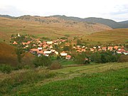
|File:Kászonfeltíz - Plaiesii de Sus.jpg|Plăieșii de Sus |
|||
|File:Jakabfalvi táj 1.jpg|Iacobeni |
|||
| ⚫ | |||
{{Communes of Harghita County}} |
{{Communes of Harghita County}} |
||
| Line 75: | Line 62: | ||
{{DEFAULTSORT:Plaiesii De Jos}} |
{{DEFAULTSORT:Plaiesii De Jos}} |
||
[[Category:Communes in Harghita County]] |
[[Category:Communes in Harghita County]] |
||
[[Category:Localities in Transylvania]] |
|||
[[Category:Székely communities]] |
[[Category:Székely communities]] |
||
Latest revision as of 22:13, 9 May 2023
Plăieșii de Jos
Kászon | |
|---|---|
![Balási Castle [ro] in Imper](/https/en.wikipedia.org/wiki/File:Balasi_kastely.jpg) Balási Castle in Imper | |
 Coat of arms | |
 Location in Harghita County | |
 Plăieșii de Jos Location in Romania | |
| Coordinates: 46°14′N 26°06′E / 46.233°N 26.100°E | |
| Country | Romania |
| County | Harghita |
| Government | |
| • Mayor (2020–2024) | Zoltán András[1] (UDMR) |
| Area | 302.52 km2 (116.80 sq mi) |
| Elevation | 719 m (2,359 ft) |
| Population (2021-12-01)[2] | 2,819 |
| • Density | 9.3/km2 (24/sq mi) |
| Time zone | EET/EEST (UTC+2/+3) |
| Postal code | 537235 |
| Area code | +40 266 |
| Vehicle reg. | HR |
| Website | www |
Plăieșii de Jos (Hungarian: Kászonaltíz or Kászon, Hungarian pronunciation: [ˈkaːson]) is a commune in Harghita County, Romania. It lies in the Székely Land, an ethno-cultural region in eastern Transylvania. The commune is composed of five villages: Cașinu Nou (Kászonújfalu), Iacobeni (Kászonjakabfalva), Imper (colloquially Imper-Doboi or Doboi, Kászonimpér), Plăieșii de Jos, and Plăieșii de Sus (Kászonfeltíz).
Geography
[edit]The commune lies on the banks of the Cașin River and its tributary, Pârâul Primejdios, in a hilly area at the foot of the Ciuc Mountains. It is located at the southeastern extremity of Harghita County, 42 km (26 mi) from the county seat, Miercurea Ciuc, on the border with Covasna County (to the south) and Bacău County (to the east).
History
[edit]The villages were part of the Székely Land region of the historical Transylvania province. They belonged to Csíkszék district. In 1850, they became part of the Udvarhely military region. After the administrative reform of Transylvania in 1876, they fell within the Csík County in the Kingdom of Hungary. After the Hungarian–Romanian War of 1919 and the Treaty of Trianon of 1920, they became part of the Kingdom of Romania and fell within Ciuc County during the interwar period. In 1940, the Second Vienna Award granted Northern Transylvania to Hungary and the villages were held by Hungary until the fall of 1944, when Romanian and Soviet troops regained control during World War II. After a brief Soviet occupation, the Romanian administration returned in March 1945. Between 1952 and 1960, the commune fell within the Magyar Autonomous Region and between 1960 and 1968 the Mureș-Magyar Autonomous Region. In 1968, the region was abolished, and since then, the commune has been part of Harghita County.
Demographics
[edit]The commune has an absolute Hungarian (Székely) majority. According to the 2011 census, it has a population of 3,012, of which 91.93% or 2,769 are Hungarian. Imper village has a Romanian majority.
Twinnings
[edit]Plăieșii de Jos is twinned with:
 Abacseke, Hungary
- Abasár, Hungary
- Ásotthalom, Hungary
- Csákvár, Hungary
- Lepsény, Hungary
 Puplinge, Switzerland
- Szajol, Hungary
References
[edit]- ^ "Results of the 2020 local elections". Central Electoral Bureau. Retrieved 9 June 2021.
- ^ "Populaţia rezidentă după grupa de vârstă, pe județe și municipii, orașe, comune, la 1 decembrie 2021" (XLS). National Institute of Statistics.
-
![Catholic church [ro] in Plăieșii de Jos](//upload.wikimedia.org/wikipedia/commons/thumb/4/49/RO_CV_Plaiesii_de_Jos_19.jpg/180px-RO_CV_Plaiesii_de_Jos_19.jpg) Catholic church in Plăieșii de Jos
Catholic church in Plăieșii de Jos -
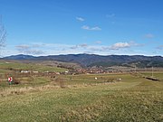 Cașinu Nou village, viewed from Plăieșii de Jos village
 -
 Plăieșii de Sus
 -
 Iacobeni
![Catholic church [ro] in Plăieșii de Jos](/https/en.wikipedia.org/wiki/File:RO_CV_Plaiesii_de_Jos_19.jpg)


