
Crêt de la Neige: Difference between revisions
Content deleted Content added
Lal.sacienne (talk | contribs) spec. cat. |
Restoring decimal points, which is how English represents decimals. |
||
| (24 intermediate revisions by 20 users not shown) | |||
| Line 1: | Line 1: | ||
{{Refimprove|date=December 2009}} |
|||
{{Infobox mountain |
{{Infobox mountain |
||
| name = Le Crêt de la Neige |
| name = Le Crêt de la Neige |
||
| photo = |
| photo = Crêt de la Neige 3.jpg |
||
| photo_caption = |
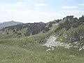
| photo_caption = Le Crêt de la Neige in Thoiry (Ain) |
||
| elevation_m = 1720 |
| elevation_m = 1720 |
||
| elevation_ref =<ref>Retrieved from the [[Institut géographique national|IGN]] topographic maps [http://www.geoportail.gouv.fr/accueil?c=5.939269232487492,46.27050985322879&z=0.00013755196946958352&l=ORTHOIMAGERY.ORTHOPHOTOS$GEOPORTAIL:OGC:WMTS(1)&l=GEOGRAPHICALGRIDSYSTEMS.MAPS.3D$GEOPORTAIL:OGC:WMTS@aggregate(1)&permalink=yes]</ref> |
|||
| elevation_ref = |
|||
| prominence_m = |
| prominence_m = 1260 |
||
| parent_peak =[[Mont Blanc]] |
| parent_peak =[[Mont Blanc]] |
||
| prominence_ref = <ref>The lowest col between the Jura and the Alps |
| prominence_ref = <ref>Retrieved from the [[Swisstopo]] topographic maps [http://s.geo.admin.ch/7f5c93742]. The lowest col between the Jura and the Alps is located at the [[Canal d’Entreroches]] (in Switzerland), at approximately 460 metres above sea level.</ref> |
||
| isolation_km = 41.3 |
|||
| ⚫ | |||
| isolation_ref = <ref>Retrieved from the [[Swisstopo]] topographic maps. The nearest point of higher elevation is northwest of the Montagne de Sous Dine.</ref> |
|||
| ⚫ | |||
| range = [[Jura Mountains]] |
| range = [[Jura Mountains]] |
||
| map = France |
| map = France |
||
| range_coordinates = |
|||
| lat_d = 46 | lat_m = 16 | lat_s = 21 | lat_NS = N |
|||
| label_position = left |
|||
| long_d = 5 | long_m= 56 | long_s= 37 | long_EW= E |
|||
| map_caption = France |
|||
| coordinates = {{coord|46|16|15|N|5|56|22|E|type:mountain_region:FR_scale:100000|format=dms|display=inline,title}} |
|||
| coordinates_ref = |
| coordinates_ref = |
||
| topo = |
| topo = |
||
| Line 22: | Line 25: | ||
}} |
}} |
||
'''Le Crêt de la Neige''' is the highest peak in the [[Jura Mountains]] and the department of [[Ain]] in France. |
'''Le Crêt de la Neige''' is the highest peak in the [[Jura Mountains]] and the department of [[Ain]] in France. Its elevation is 1720 m above sea level (reported as 1718 m before 2003). Its [[Topographic prominence|prominence]] is 1260 m. It is located in the commune of [[Thoiry, Ain|Thoiry]]. In 2024, a team of researchers locates the actual highest peak in a protected area and measures its elevation at 1720.83 m, while they found the geodetic marker at Crêt de la Neige at 1718.06 m elevation<ref>Hetényi G., Chagros A.-M., Lemke K., Maharaj A., Baron L. (2024). Détermination du point culminant du massif du Jura. Mémoires de Géologie (Lausanne), n° 51, 6 pp. [https://serval.unil.ch/notice/serval:BIB_74DF5BB40E91]</ref>. |
||
<gallery> |
|||
| ⚫ | |||
Image:CrêtdeLaNeige.jpeg|Summit of the Crêt de la Neige, with [[Le Reculet]] in the background |
|||
</gallery> |
|||
{{clear}} |
|||
==References== |
==References== |
||
{{reflist}} |
{{reflist}} |
||
{{Authority control}} |
|||
| ⚫ | |||
{{DEFAULTSORT:Cret De La Neige}} |
|||
[[Category:Mountains of Ain]] |
[[Category:Mountains of Ain]] |
||
[[Category:Mountains of the Jura]] |
[[Category:Mountains of the Jura]] |
||
{{Ain-geo-stub}} |
{{Ain-geo-stub}} |
||
[[de:Crêt de la Neige]] |
|||
[[es:Crêt de la Neige]] |
|||
[[fr:Crêt de la Neige]] |
|||
[[it:Crêt de la Neige]] |
|||
[[ka:ნეჟნი]] |
|||
[[nl:Crêt de la Neige]] |
|||
[[no:Crêt de la Neige]] |
|||
[[nn:Crêt de la Neige]] |
|||
[[pl:Crêt de la Neige]] |
|||
[[pt:Crêt de la Neige]] |
|||
[[ro:Crêt de la Neige]] |
|||
Latest revision as of 23:29, 4 September 2024
| Le Crêt de la Neige | |
|---|---|
 Le Crêt de la Neige in Thoiry (Ain) | |
| Highest point | |
| Elevation | 1,720 m (5,640 ft)[1] |
| Prominence | 1,260 m (4,130 ft)[2] |
| Parent peak | Mont Blanc |
| Isolation | 41.3 km (25.7 mi)[3] |
| Coordinates | 46°16′15″N 5°56′22″E / 46.27083°N 5.93944°E |
| Geography | |
 Le Crêt de la Neige France | |
| Location | Ain, Rhône-Alpes, France |
| Parent range | Jura Mountains |
Le Crêt de la Neige is the highest peak in the Jura Mountains and the department of Ain in France. Its elevation is 1720 m above sea level (reported as 1718 m before 2003). Its prominence is 1260 m. It is located in the commune of Thoiry. In 2024, a team of researchers locates the actual highest peak in a protected area and measures its elevation at 1720.83 m, while they found the geodetic marker at Crêt de la Neige at 1718.06 m elevation[4].
-
 Looking towards Geneva from the summit
 -
 Summit of the Crêt de la Neige, with Le Reculet in the background


References
[edit]- ^ Retrieved from the IGN topographic maps [1]
- ^ Retrieved from the Swisstopo topographic maps [2]. The lowest col between the Jura and the Alps is located at the Canal d’Entreroches (in Switzerland), at approximately 460 metres above sea level.
- ^ Retrieved from the Swisstopo topographic maps. The nearest point of higher elevation is northwest of the Montagne de Sous Dine.
- ^ Hetényi G., Chagros A.-M., Lemke K., Maharaj A., Baron L. (2024). Détermination du point culminant du massif du Jura. Mémoires de Géologie (Lausanne), n° 51, 6 pp. [3]
| International | |
|---|---|
| National | |
This Ain geographical article is a stub. You can help Wikipedia by expanding it. |