
Werneuchen: Difference between revisions
Content deleted Content added
m rm unused infobox parameters |
NeilTarrant (talk | contribs) →Demography: Plot was updated on 22:38, 29 June 2021, update to reflect changes |
||
| Line 27: | Line 27: | ||
<gallery widths="250" heights="200"> |
<gallery widths="250" heights="200"> |
||
File:Bevölkerungsentwicklung Werneuchen.pdf|Development of Population since 1875 within the Current Boundaries (Blue Line: Population; Dotted Line: Comparison to Population Development of Brandenburg state; Grey Background: Time of Nazi rule; Red Background: Time of Communist rule) |
File:Bevölkerungsentwicklung Werneuchen.pdf|Development of Population since 1875 within the Current Boundaries (Blue Line: Population; Dotted Line: Comparison to Population Development of Brandenburg state; Grey Background: Time of Nazi rule; Red Background: Time of Communist rule) |
||
File:Bevölkerungsprognosen Werneuchen.pdf|Recent Population Development and Projections (Population Development before Census 2011 (blue line); Recent Population Development according to the [[Census in Germany]] in 2011 (blue bordered line); Official projections for 2005-2030 (yellow line); for |
File:Bevölkerungsprognosen Werneuchen.pdf|Recent Population Development and Projections (Population Development before Census 2011 (blue line); Recent Population Development according to the [[Census in Germany]] in 2011 (blue bordered line); Official projections for 2005-2030 (yellow line); for 2017-2030 (purple line); and for 2020-2030 (green line). |
||
</gallery> |
</gallery> |
||
Revision as of 10:01, 31 October 2021
Werneuchen | |
|---|---|
 Church in Willmersdorf | |
 Flag  Coat of arms | |
Location of Werneuchen within Barnim district  | |
 Werneuchen  Werneuchen | |
| Coordinates: 52°37′59″N 13°43′59″E / 52.63306°N 13.73306°E | |
| Country | Germany |
| State | Brandenburg |
| District | Barnim |
| Subdivisions | 9 Ortsteile |
| Government | |
| • Mayor (2019–27) | Frank Kulicke[1] (Ind.) |
| Area | |
| • Total | 116.34 km2 (44.92 sq mi) |
| Elevation | 75 m (246 ft) |
| Population (2022-12-31)[2] | |
| • Total | 9,369 |
| • Density | 81/km2 (210/sq mi) |
| Time zone | UTC+01:00 (CET) |
| • Summer (DST) | UTC+02:00 (CEST) |
| Postal codes | 16356 |
| Dialling codes | 033398 |
| Vehicle registration | BAR |
| Website | www.stadt-werneuchen.de |

Werneuchen (German pronunciation: [vɛɐ̯ˈnɔɪ̯çn̩] ) is a town in Brandenburg, Germany, in the district of Barnim northeast of Berlin within the metropolitan area. Most of the population of Werneuchen commutes to Berlin.[citation needed]
Demography
-
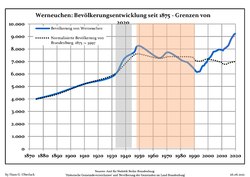 Development of Population since 1875 within the Current Boundaries (Blue Line: Population; Dotted Line: Comparison to Population Development of Brandenburg state; Grey Background: Time of Nazi rule; Red Background: Time of Communist rule)
 -
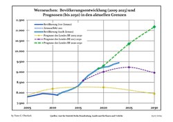 Recent Population Development and Projections (Population Development before Census 2011 (blue line); Recent Population Development according to the Census in Germany in 2011 (blue bordered line); Official projections for 2005-2030 (yellow line); for 2017-2030 (purple line); and for 2020-2030 (green line).


|
|
|
International relations
Werneuchen is twinned with:
References
- ^ Landkreis Barnim Wahl der Bürgermeisterin / des Bürgermeisters, accessed 30 June 2021.
- ^ "Bevölkerungsentwicklung und Bevölkerungsstandim Land Brandenburg Dezember 2022" (PDF). Amt für Statistik Berlin-Brandenburg (in German). June 2023.
- ^ Detailed data sources are to be found in the Wikimedia Commons.Population Projection Brandenburg at Wikimedia Commons
External links
![]() Media related to Werneuchen at Wikimedia Commons
Media related to Werneuchen at Wikimedia Commons
Towns and municipalities in Barnim district | ||
|---|---|---|
 | ||
| International | |
|---|---|
| National | |
This Brandenburg location article is a stub. You can help Wikipedia by expanding it. |