File:Lageplan Burg Friedlingen.jpg

Size of this preview: 800 × 498 pixels. Other resolutions: 320 × 199 pixels | 640 × 398 pixels | 1,159 × 721 pixels.
Original file (1,159 × 721 pixels, file size: 143 KB, MIME type: image/jpeg)
Captions
Captions
Add a one-line explanation of what this file represents
Summary
[edit]
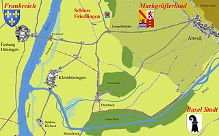
| Description | Map of Area Festung Hüningen, Burg Friedlingen |
| Date | |
| Source | Own work |
| Author | Benediktleander |
Licensing
[edit]
I, the copyright holder of this work, hereby publish it under the following licenses:

|
Permission is granted to copy, distribute and/or modify this document under the terms of the GNU Free Documentation License, Version 1.2 or any later version published by the Free Software Foundation; with no Invariant Sections, no Front-Cover Texts, and no Back-Cover Texts. A copy of the license is included in the section entitled GNU Free Documentation License. |
| This file is licensed under the Creative Commons Attribution-Share Alike 3.0 Unported license. | ||
| ||
| This licensing tag was added to this file as part of the GFDL licensing update. |
You may select the license of your choice.
File history
Click on a date/time to view the file as it appeared at that time.
| Date/Time | Thumbnail | Dimensions | User | Comment | |
|---|---|---|---|---|---|
| current | 14:42, 20 February 2008 | | 1,159 × 721 (143 KB) | Benediktleander (talk | contribs) | Umgebungskarte von Schloss Friedlingen im Markgräflerland, selbst erstellte Karte auf Grundlage verschiedener historischer Karten |
| 00:40, 20 February 2008 |  | 1,159 × 721 (145 KB) | Benediktleander (talk | contribs) | Umgebungskarte von Schloss Friedlingen im Markgräflerland, selbst erstllte Karte | |
| 00:37, 20 February 2008 |  | 1,159 × 721 (145 KB) | Benediktleander (talk | contribs) | Eigene Darstellung | |
| 13:25, 19 February 2008 |  | 353 × 202 (24 KB) | Benediktleander (talk | contribs) | Schloss Friedlingen bei Weil am Rhein | |
| 12:19, 19 February 2008 |  | 353 × 202 (27 KB) | Benediktleander (talk | contribs) | {{Information |Description=Map of Area Festung Hüningen, Burg Friedlingen |Source=eigene Arbeit |Date=19.02.2008 |Author= Benediktleander |Permission= |other_versions= }} |
You cannot overwrite this file.
File usage on Commons
There are no pages that use this file.
File usage on other wikis
The following other wikis use this file:
- Usage on als.wikipedia.org
- Usage on de.wikipedia.org
- Usage on ru.wikipedia.org